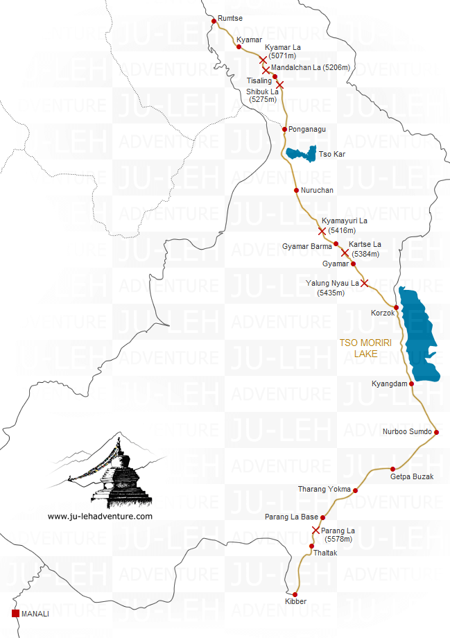
Rumtse to Kibber trek via Tso Moriri
Duration: 14 days
Difficulty: level 5
Distance: 197 km
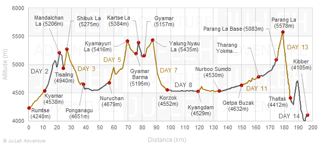
Max elevation: 5578m
Elevation gain / loss: +4764m / -4899m
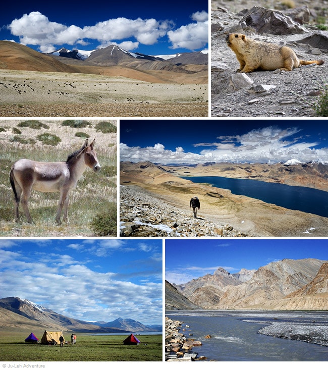
This trek will take you through the Changthang region, a beautiful high-altitude plateau with unique landscapes in southeastern Ladakh. Enjoy the turquoise colour lakes of Tso Kar and Tso Moriri, meet the nomads and perhaps see some wild animals. From Tso Moriri to Kibber, the trek follows the ancient trade route between Ladakh and Spiti. This trek is the combination of the Rumtse to Tso Moriri trek and the Tso Moriri to Kibber trek.


Itinerary
Day 1: Rumtse - Kyamar
Time: 4 hrs
Distance: 10.9 km
Elevation gain / loss: +298m / -0m
| - | ascend the valley of Kyamar which was once called the salt road. It is through this valley that the salt from Tso Kar lake was brought to Leh and the Indus valley |
| - | the landscapes are soft and harmonious |

Day 2: Kyamar - Kyamar La - Mandalchan La - Tisaling
Time: 6-7 hrs
Distance: 13.5 km
Elevation gain / loss: +786m / -384m
| - | ascend the Kyamar La from where you will have a stunning view of the Changthang mountains |
| - | descend towards Tiri Doksa, a seasonal shepherds shelter |
| - | continue walking, start another ascent to the Mandalchan La and descend again towards Tisaling |

Day 3: Tisaling - Shibuk La - Ponganagu
Time: 6 hrs
Distance: 14.3 km
Elevation gain / loss: +377m / -666m
| - | walk towards the Shibuk La |
| - | from the top, enjoy the incredible view of Tso Kar lake surrounded by snowcapped mountains |
| - | descend into the valley that leads to Ponganagu next to Tso Kar lake |
| - | the place is known for wildlife sightings such as marmots, ibex, kiang (wild asses) and migratory birds |

Day 4: Ponganagu - Nuruchan
Time: 5-6 hrs
Distance: 17.8 km
Elevation gain / loss: +173m / -145m
| - | the trek begins walking along the bank of Tso Kar lake. Tso Kar means 'white lake' because of the deposits of salt on its shore |
| - | continue your walk to Nuruchan |

Day 5: Nuruchan - Kyamayuri La - Gyamar Barma
Time: 7-8 hrs
Distance: 19.3 km
Elevation gain / loss: +855m / -339m
| - | you need to cross two passes, Horlam Kongka La (4900m) and Kyamayuri La (5416m) before you arrive to Gyamar Barma |

Day 6: Gyamar Barma - Kartse La - Gyamar
Time: 3 hrs
Distance: 5.7 km
Elevation gain / loss: +213m / -251m
| - | climb the Kartse La and descend to Gyamar |

Day 7: Gyamar - Yalung Nyau La - Korzok
Time: 5-6 hrs
Distance: 16.3 km
Elevation gain / loss: +300m / -905m
| - | climb up the Yalung Nyau La and enjoy the superb view of Tso Moriri lake from the pass |
| - | walk down to reach Korzok village, situated on the bank of Tso Moriri |

Day 8: Korzok - Kyangdam
Time: 6-7 hrs
Distance: 21.6 km
Elevation gain / loss: +25m / -48m
| - | walk along the west bank of the lake, the trail is mostly level and you will have fantastic views of the Mentok range on the right and Chamser & Lungser Kangri across the lake |

Day 9: Kyangdam - Nurboo Sumdo
Time: 4-5 hrs
Distance: 14.9 km
Elevation gain / loss: +97m / -96m
| - | from Kyangdam the scenery changes dramatically and you enter the river valley of Parang Chu |

Day 10: Nurboo Sumdo - Getpa Buzak
Time: 4-5 hrs
Distance: 15.8 km
Elevation gain / loss: +102m / -0m
| - | walk along the river heading south to Getpa Buzak |

Day 11: Getpa Buzak - Tharang Yokma
Time: 4-5 hrs
Distance: 12.2 km
Elevation gain / loss: +201m / -47m
| - | continue walking along the Parang Chu river, walk up and down on rolling hills before reaching Tharang Yokma |

Day 12: Tharang Yokma - Parang La Base
Time: 4-5 hrs
Distance: 12.5 km
Elevation gain / loss: +307m / -10m
| - | this is a nice walk across a vast meadow while following the Parang Chu river to the base of the Parang La |

Day 13: Parang La Base - Parang La - Thaltak
Time: 5-6 hrs
Distance: 9.8 km
Elevation gain / loss: +495m / -1166m
| - | start walking up gradually to cross the Parang La, the highest pass of the trek |
| - | from the pass, there is a fantastic view of the Spiti valley |
| - | steep descent into a gorge |

Day 14: Thaltak - Kibber
Time: 5-6 hrs
Distance: 12.3 km
Elevation gain / loss: +535m / -842m
| - | cross a small pass and follow the trail going down to Kibber |

Getting to / from the trek
| - | it takes 2 hours to drive from Leh to Rumtse (80 km) |
| - | Kibber is 215 km from Manali and 550 km from Leh |
On the way from Leh to Rumtse, it is worth taking some extra time to stop and visit the highlights in the area, check the Indus valley tour to Hemis for more details.
All the itineraries can be customized to suit your own special interests, preferences and abilities. Please contact us for more information.


 Hemis to Tso Moriri


